Explore & Interact with other St. Louis Area Surveyors
✧ Membership ✧ Education Opportunities ✧ Career Advancement ✧2026 Chapter Meeting Schedule – Expandable sections
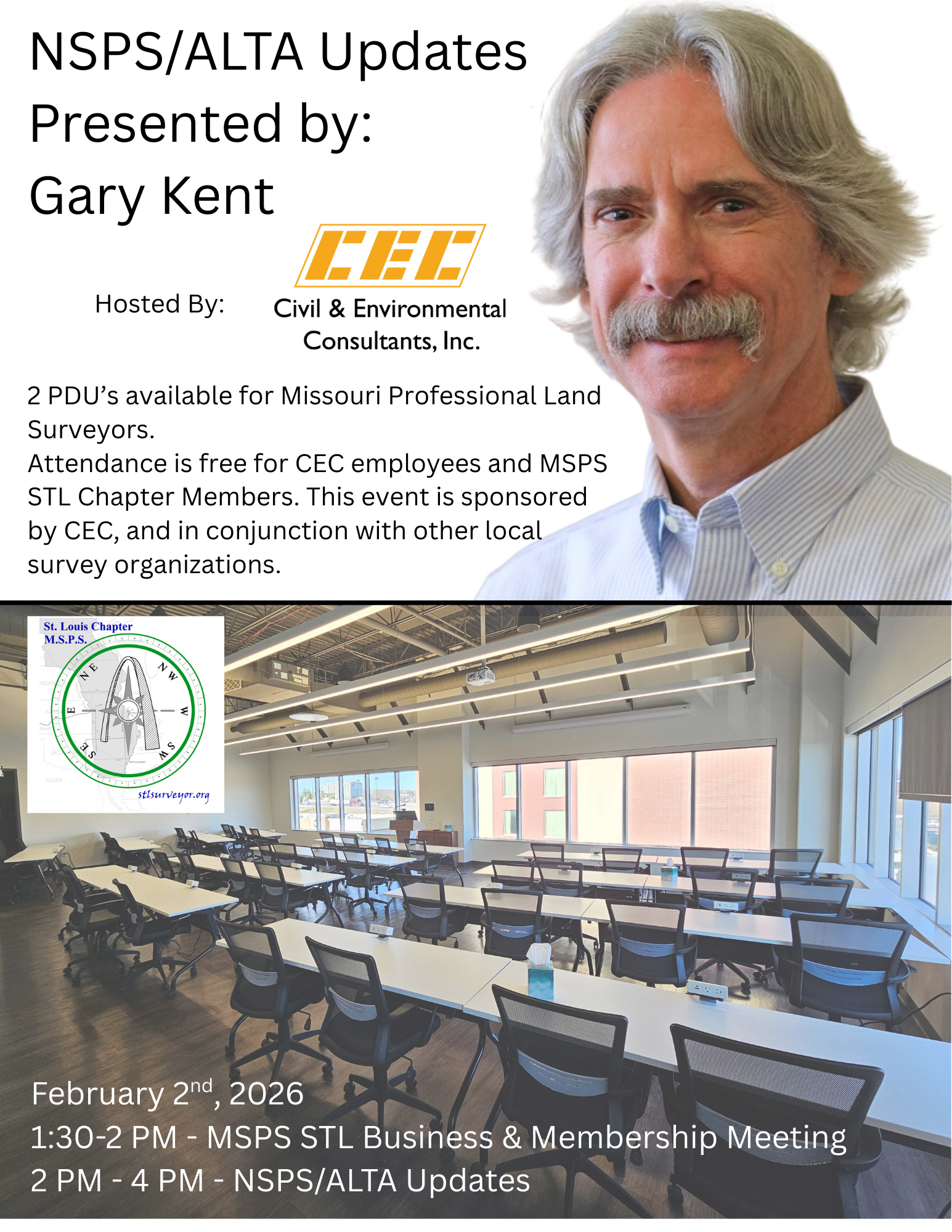
2026 ALTA Updates Presented by Gary Kent - Spring Membership Meeting - February 2nd

2026 ALTA/NSPS Updates Presented by Gary Kent
1:30-2PM – MSPS STL Business Meeting
2pm – 4pm ALTA/NSPS Updates Presented by Gary Kent
Hosted at CEC, St. Louis
1450 Beale St Suite 305, St Charles, MO 63303
Refreshments & Snacks will be provided by CEC.
2026 Official Final ALTA/NSPS Standards
2026 Official Redline ALTA/NSPS Standards
Summer Membership Meeting - June, 2026
Fall Membership Meeting - September 2nd or 9th, 2026
Our Fall 2026 Membership meeting is tentatively scheduled for September, in Washington, MO.
Winter Membership Meeting - December, 2026
Our Winter 2026 Membership meeting is tentatively scheduled for December.
Past Meetings
Winter Membership Meeting - December 10th, 2025
Our winter membership meeting will be at Rosalita’s Cantina.

December 10th, 6pm – 7:30pm.
We will have our raffle drawing for the winner of our Scholarship Fundraiser.
The MSPS STL Board of Directors and membership will elect new officers and directors for the 2026 year.
The discussion will begin with Units of Measure, and handy conversions that surveyors use regularly and how these have changed through the years.
The opening conversation will lead into a Surveyor’s Round-Table Discussion.
This has been approved for 1.5 PDUs by the Board of Registration, and is on the “Current List of Preapproved Courses for PDU’s.”.
2025 Gun Raffle Tickets for Sale!
The St. Louis Chapter MSPS fundraiser for 2025
Henry All-Weather .45-70 Raffle!

Golf Outing w/ IPLSA Southwest Chapter 2025
End of Summer Membership Meeting - August 27th, 2025
Some Riparian Boundary Surveys and Litigation I’ve Seen– Dr. Richard L. Elgin, PS, PE
August 27th, 2025Â at the James W. Rennick Riverfront Park, Washington, MO.
This meeting has been approved for 1.5 PDU’s by APEPLSPLA and is on the list of Pre-Approved Activities.
6:00 – 6:30 PM – St. Louis Chapter Business Meeting, Scholarship Fundraiser Tickets, while enjoying BBQ along the Missouri River by BFA, Inc.
6:30-7:30 PM – Presentation by Dr. Dick Elgin who will be discussing riparian boundaries and litigation examples. Outline here.

Summer Membership Meeting - June 18th, 2025
Our June 18th Membership meeting will be held at B. Halls 2 – The Event Space of the Family Grill.
3752 Monticello Plaza Drive, O’Fallon, MO 63304.

We will be in the private room and attendees may order dinner and drinks from the regular menu.
Time: 6:00 PM – 7:30 PM
The presenter will be Matt Winkler & John Schaeffer, on behalf of Arch City Title, St. Louis Title, Benchmark Title and Security Title. The PDF outline for the evening’s presentation is HERE. The will be discussing title research related to surveys and the title research industry looking ahead, it is sure to be an informative and interesting evening. This will also be a great opportunity for surveyors from multiple counties, in MO & IL to meet the title company representatives.

Spring Membership Meeting - March 26th 2025
Outline for MSPSSTL – 2025 Spring Membership Meeting
Time: 6:00 PM – 7:30 PM
Location: Office of TWM, Inc. 3701 S Lindbergh Blvd Suite 100, St. Louis, MO 63127
6:00 – 6:30 PM – Business Meeting, Non-Profit organization status, Scholarship Foundation, website updates, Ongoing St. Louis City/County limits original stones located and updated database and calculations by companies on website.
6:30 – 7:00 PM – New Survey Technician program, certified by the DOL and administrated by the StL Construction Forum. St. Louis Community College’s involvement, and a description of survey courses offered, career advancement and tuition paid for by St. Louis County Workforce Development.
Presentation to membership and open discussion with Tom McGovern from St. Louis County Community College, Tom Finan & Diana Wilhold from StL Construction Forum will present.
7:00 – 7:30 PM – AI in Surveying Presentation. Daily routines with AI, short-cutting work-flows. Walk-through Microsoft Office apps with AI assistance. Thoughtful prompting for precise outputs. Surveyor’s perspectives on AI questioning, input and liability during day-to-day use.
Demonstration showcasing useful AI platforms that can create detailed presentations and deliverables for projects.
Demonstration showcasing detailed prompting to create a Python app that allows coordinate data entry and calculates results in a user created input/output form or file.


December 28th, 1803.
Mackay and Evans Journals.
LEWIS & CLARK EXPEDITION.
Photo: John Evans’ Map Sheet 6. Courtesy Beinecke Rare Book and Manuscript Library, Yale University, collections.library.yale.edu/catalog/2002449.
At Wood River, CLARK reports “nothing remarkable to day” other than two deer are killed.
Elsewhere, LEWIS updates THOMAS JEFFERSON as to his progress gathering intelligence in Cahokia and St. Louis: a census of Louisiana and journals and maps from explorers JOHN EVANS and JAMES MACKAY.
MACKAY and EVANS JOURNALS
Cahokia December 28th 1803.
"Dear Sir [Thomas Jefferson],
I have also obtained Ivins’s and Mac Kay’s journal up the Missouri, it is in French & is at present in the hands of Mr. Hay, who has promised to translate it for me; I am also promised by Mr. Hay copy of his journal from Michilimackinack to the Assinaboin river in the north
MERIWETHER LEWIS. CAPT.
1st. U.S. Regt. Infty."
JAMES MACKAY'S and JOHN EVANS' journals and maps provided the most accurate and detailed information of the geography between St. Louis and the Knife River Villages available at that time. For the map’s original legend, a comparison with William Clark’s map of the same area, and a description of the Souris River Trail, see Clark’s Fort Mandan Maps.
THREE LOUISIANA MAPS
Cahokia December 28th 1803.
"Dear Sir,
I have obtained three maps; one of the Osages river, before mentioned, a general map of Uper Louisiana, and a map of the Missouri river, from it’s mouth to the Mandane [Mandan] nation
MERIWETHER LEWIS. CAPT.
1st. U.S. Regt. Infty."
NOTE:
Winter Camp at Wood River (Camp Dubois) is a High Potential Historic Site along the Lewis and Clark National Historic Trail.
Discover More
The Lewis and Clark Expedition: Day by Day by Gary E. Moulton (University of Nebraska Press, 2018).
#MissouriSocietyOfProfessionalSurveyors #StLHistory #landsurveying #ProfessionalSurveyor #Surveyors #surveyor #surveying #LifeOfASurveyor #StlSurveyor #surveyors #landsurveyor #professionalsurveyor #idahosurveygroup #stlsurveyor #lifeofasurveyor #SurveryorsHistoricalSociety #nebraskasurvey #professionalsurveyors #StLouismo #VoyageOfDiscovery #StCharlesmo #SIUE ... See MoreSee Less
Comment on Facebook
December 25th, 1803.
Wood River Christmas.
LEWIS & CLARK EXPEDITION.
Photo: Camp Dubois Christmas by Michael Haynes. © Michael Haynes, www.mhaynesart.com.
Christmas Frolic
"I was wakened by a Christmas discharge found that Some of the party had got Drunk the men frolicked and hunted all day, Snow this morning, Ice run all day, Several Turkey Killed Shields returned with a cheese & 4 lb butter,
—WILLIAM CLARK"
Indian Visitors
"Three Indians Come to day to take Christmas with us, I gave them a bottle of whiskey and they went off after informing me that a great talk had been held and that all the nations were going to war against the Ozous in 3 months, one informed me that a English man 16 ms. from here told him that the Americans had the Countrey and no one was allowed to trade &c. I explained the Intention of Govmt to him, and the Caus of the possession . . . .
—WILLIAM CLARK"
Winter Camp at Wood River (Camp Dubois) is a High Potential Historic Site along the Lewis and Clark National Historic Trail managed by the U.S. National Park Service. The site, near Hartford, Illinois, is managed as Lewis and Clark State Historic Site and is open to the public.
Discover More
The Lewis and Clark Expedition: Day by Day by Gary E. Moulton (University of Nebraska Press, 2018). The story in prose, 14 May 1804–23 September 1806.
The Lewis and Clark Journals: An American Epic of Discovery (abridged) by Gary E. Moulton (University of Nebraska Press, 2003). Selected journal excerpts, 14 May 1804–23 September 1806.
The Lewis and Clark Journals. by Gary E. Moulton (University of Nebraska Press, 1983–2001). The complete story in 13 volumes.
Post navigation
#MissouriSocietyOfProfessionalSurveyors #LifeOfASurveyor #surveyor #surveying #Surveyors #ProfessionalSurveyor #landsurveying #surveyors #landsurveyor #professionalsurveyor #landsurveyorsunited #Surveying #surveylife #SurveryorsHistoricalSociety #Surveyor #LandSurveying #mspsstl #CorpsofDiscovery #StLHistory ... See MoreSee Less
Comment on Facebook
December 24th, 1803.
American Immigrants.
LEWIS & CLARK EXPEDITION.
Working in Cahokia and St. Louis, LEWIS finds that many American emigrants have arrived in anticipation of the Louisiana transfer. At the Wood River camp, roofs are completed and passing boatmen visit with CLARK.
American Emigrants
"Cahokia December 28th 1803.
Dear Sir,
Many persons from different parts of the U’States, particularly N. Carolina, have visited Louisiana since the cession of that country to the U’States has been made known; these persons were in serch of some eligible positions to form settlements as soon as the American government was in operation in that quarter. They appear generally pleased with the country, and will no doubt make a favourable report on their return.
MERIWETHER LEWIS. CAPT.
1st. U.S. Regt. Infty."
Boat Men
"two French Perogues pass up the river to day, and peregoue with black guard Americans, passed down the river . . . . a French man who passed up to day told me that a man of abt. 30 years of age well acquainted with the Missoures for 8 years, wishes to go with me
—WILLIAM CLARK"
NOTE:
Winter Camp at Wood River (Camp Dubois) is a High Potential Historic Site along the Lewis and Clark National Historic Trail managed by the U.S. National Park Service. The site, near Hartford, Illinois, is managed as Lewis and Clark State Historic Site and is open to the public.
Discover More
The Lewis and Clark Expedition: Day by Day by Gary E. Moulton (University of Nebraska Press, 2018). The story in prose, 14 May 1804–23 September 1806.
The Lewis and Clark Journals: An American Epic of Discovery (abridged) by Gary E. Moulton (University of Nebraska Press, 2003). Selected journal excerpts, 14 May 1804–23 September 1806.
The Lewis and Clark Journals. by Gary E. Moulton (University of Nebraska Press, 1983–2001). The complete story in 13 volumes.
#LifeOfASurveyor #landsurveying #Surveyors #MissouriSocietyOfProfessionalSurveyors #ProfessionalSurveyor #surveying #surveyor #surveyors #landsurveyor #professionalsurveyor #landsurvey #surveylife #stlsurveyor #surveyorsunited #montanasurveyor #SurveryorsHistoricalSociety #stlmsps #StCharlesmo #VoyageOfDiscovery ... See MoreSee Less
Comment on Facebook
December 22nd, 1803.
Prying the Barge.
LEWIS & CLARK EXPEDITION.
Photo: Courtesy of the U.S. Army Center of Military History.
Prying the Barge
"a verry great Sleat this morning, the river Coverd with running Ice, and falls verry fast 15 Inches last night the boat a ground in the Creek, I had pries fixed along to Support the boat, and all the heavy articles taken out in Front & Center and Sto[r]ed under a guard on the bank—
—WILLIAM CLARK"
Tennessee Recruits
"at 3 oClock Drewyer & 8 men 2 horses arrive from Tennessee, those men are not such I was told was in readiness at Tennessee for this Comd.
—WILLIAM CLARK"
(The soldiers were from John Campbell’s company from Fort Southwest Point.)
Gratiot’s Offer
"recved a Letter from Cap Lewis also one from Mr. Gratiot offering a horse and his Services to Cap L & my self in any way.
—WILLIAM CLARK"
Lewis’s Stealth
"Cahokia December 28th 1803.
Dear Sir,
I have no doubt, as soon as the American government takes effect in Louisiana, that many of the best informed of it’s inhabitants in order to make themselves known to it, will unsolicited come forward with much interesting information, till then, every thing must be obtained by stealth.
MERIWETHER LEWIS. CAPT.
1st. U.S. Regt. Infty."
Discover More
The Lewis and Clark Expedition: Day by Day by Gary E. Moulton (University of Nebraska Press, 2018). The story in prose, 14 May 1804–23 September 1806.
The Lewis and Clark Journals: An American Epic of Discovery (abridged) by Gary E. Moulton (University of Nebraska Press, 2003). Selected journal excerpts, 14 May 1804–23 September 1806.
The Lewis and Clark Journals. by Gary E. Moulton (University of Nebraska Press, 1983–2001). The complete story in 13 volumes.
#Surveyors #MissouriSocietyOfProfessionalSurveyors #surveying #ProfessionalSurveyor #landsurveying #surveyor #LifeOfASurveyor #surveyors #landsurveyor #professionalsurveyor #landsurveyorsunited #montanasurveyors #Surveying #SurveryorsHistoricalSociety #SurveyorsHistoricalSociety #professionalsurveyors #VoyageOfDiscovery #StCharlesmo #StlSurveyor ... See MoreSee Less
Comment on Facebook
December 20th, 1803.
Louisiana's Formal Transfer.
LEWIS & CLARK EXPEDITION.
At the Wood River construction site, CLARK uses the Army Commissary’s wagons to haul logs and by the end of day, the enlisted men move into their huts.
"I Detain the waggon to haul logs for my building . . . . hauled Logs to day with the Comosaries Teem men move into ther huts this eveninge.
—WILLIAM CLARK"
In New Orleans, officials conduct the formal transfer of the city and lower Louisiana from France to the United States.
NOTE:
Winter Camp at Wood River (Camp Dubois) is a High Potential Historic Site along the Lewis and Clark National Historic Trail managed by the U.S. National Park Service. The site, near Hartford, Illinois, is managed as Lewis and Clark State Historic Site and is open to the public.
Discover More
The Lewis and Clark Expedition: Day by Day by Gary E. Moulton (University of Nebraska Press, 2018). The story in prose, 14 May 1804–23 September 1806.
The Lewis and Clark Journals: An American Epic of Discovery (abridged) by Gary E. Moulton (University of Nebraska Press, 2003). Selected journal excerpts, 14 May 1804–23 September 1806.
The Lewis and Clark Journals. by Gary E. Moulton (University of Nebraska Press, 1983–2001). The complete story in 13 volumes.
#Surveyors #landsurveying #MissouriSocietyOfProfessionalSurveyors #LifeOfASurveyor #surveying #surveyor #ProfessionalSurveyor #surveyors #landsurveyor #professionalsurveyor #landsurvey #missourisocietyofprofessionalsurveyors #landsurveyorsunited #montanasurveyors #Surveying #surveylife #stlsurveyor #lifeofasurveyor #SurveryorsHistoricalSociety #SurveyorsHistoricalSociety #Surveyor #LandSurveying #professionalsurveyors #StCharlesmo #VoyageOfDiscovery ... See MoreSee Less
Comment on Facebook
December 19th, 1803.
Surveyor Antoine Soulard.
LEWIS & CLARCK EXPEDITION.
Photo: New Cabins at Camp River Dubois, by Michael Haynes. Photo provided by Lewis & Clark State Historic Site, Hartford, Illinois. (Altered: the snow, trees, and icy road are computer generated.)
ANTOINE SOULARD.
"Cahokia December 28th 1803.
Dear Sir,
I found the means to obtain an introduction to Monsr. Soulard, the Surveyor Genl., and was recieved by him in a very friendly manner; he gave me many unqualified assurances of his willingness to serve me, and his readyness to give me any information of which, he was possessed, in relation to the province.
MERIWETHER LEWIS. CAPT.
1st. U.S. Regt. Infty."
Lewis’s meeting with Soulard occurred between December 10 and 28. During this period, Lewis traveled between Cahokia and St. Louis.
Wagons with food and other provisions arrive at winter camp at Wood River—Camp River Dubois. In Cahokia, Lewis writes a letter to President Jefferson telling him that the Spanish King’s surveyor general of Upper Louisiana, Antoine Soulard, will share geographic information about the West.
Discover More
The Lewis and Clark Expedition: Day by Day by Gary E. Moulton (University of Nebraska Press, 2018).
The Lewis and Clark Journals. by Gary E. Moulton (University of Nebraska Press, 1983–2001). The complete story in 13 volumes.
Ref: The Lewis & Clark Trail Alliance.
#surveying #landsurveying #ProfessionalSurveyor #Surveyors #MissouriSocietyOfProfessionalSurveyors #surveyor #LifeOfASurveyor #surveyors #landsurveyor #professionalsurveyor #idahosurveygroup #landsurvey #missourisocietyofprofessionalsurveyors #landsurveyorsunited #montanasurveyors #Surveying #stlsurveyor #SurveryorsHistoricalSociety #southdakotasurvey #SurveyorsHistoricalSociety #surveyorshistoricalsociety #Surveyor #professionalsurveyors #StCharlesmo #StlSurveyor
Winter Camp at Wood River (Camp Dubois) is a High Potential Historic Site along the Lewis and Clark National Historic Trail managed by the U.S. National Park Service. The site, near Hartford, Illinois, is managed as Lewis and Clark State Historic Site and is open to the public. ... See MoreSee Less
Comment on Facebook